Many people understand counties as administrative units, based on a local authority or council. In reality, whilst local government is barely more than a century old, many of our actual counties have existed for well over a thousand years and cannot be defined by which recently formed administration oversees rubbish collection or issues parking permits! More on this can be found at the County Definitions page but the series of maps below, graphically illustrate the tremendous differences between the real counties and the territories administered by local authorities which either inappropriately make use of county names or obscure real counties.
County Durham
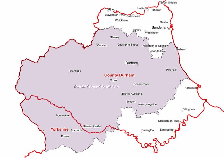
The true County Durham boundary is shown in red. The purple area is the territory administered by Durham County Council which does not include such famous county towns as Sunderland and Gateshead in the north nor Hartlepool, Darlington and Stockton-On-Tees in the south but does cover a great swathe of the North Riding of Yorkshire! Northern County Durham and southern Northumberland are administered separately from the rest of their respective counties as shown in green on the below map
but this administrative convenience has no impact on the two actual counties as entities.
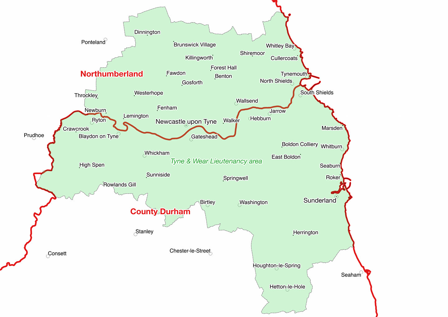
Northumberland
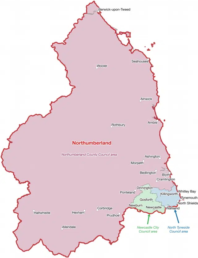 The county is administered by one council that covers most of its territory and two that administer its south eastern portion, these are depicted in purple, green, and blue on the above map and are respectively Northumberland Council , Newcastle City Council and North Tyneside Council. Irrespective of these administrative arrangements however, everything within the solid red line is the county of Northumberland and residents of Newcastle and its urban surround can be proud of being Northumbrians.
Lancashire, Cheshire and Yorkshire

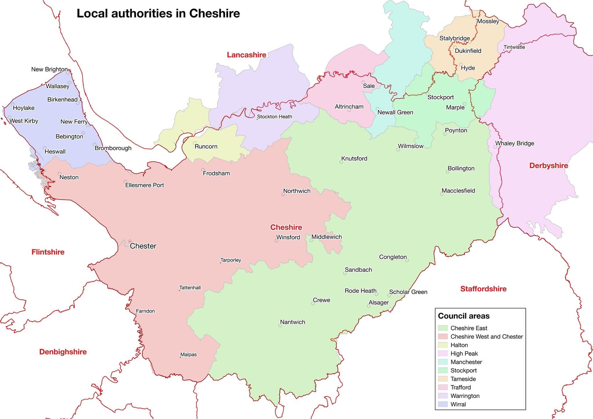
South eastern Lancashire is administered by a local authority area named Greater Manchester, shown in grey, which also oversees civic matters in adjacent parts of Cheshire, Yorkshire and even a portion of Derbyshire! All the respective counties covered, remain as distinct entities however, unchanged in shape or size. The county of Cheshire itself is depicted below, as can be seen several varying authorities administer the territory of the county, a few of which also administer territory across the county boundary. None of these bodies defines any county.
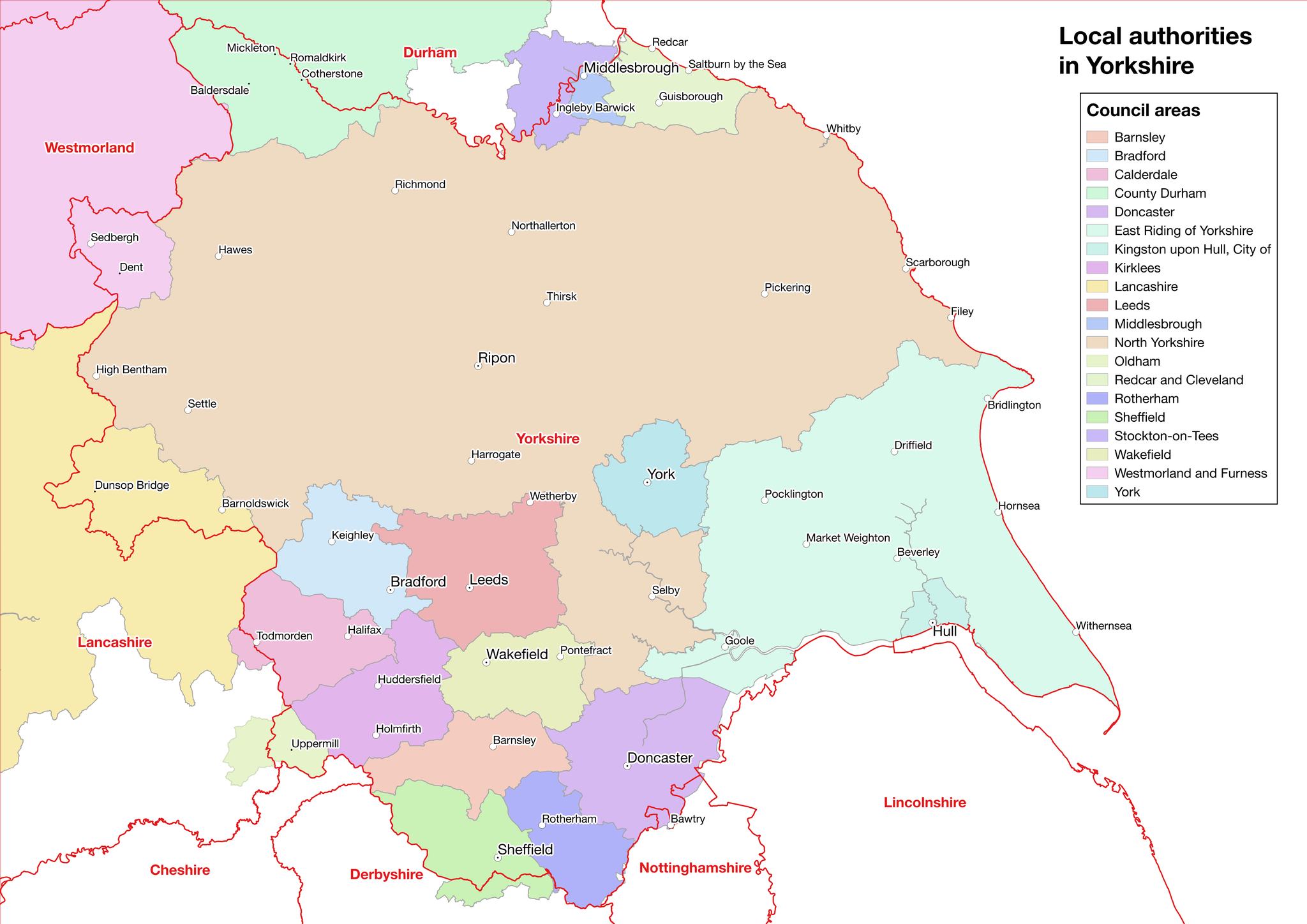
Below is a map of the local authorities which administer Yorkshire, whose boundary is shown in red. Everything withing this boundary is Yorkshire albeit that a number of administrative areas straddle the real county boundary, as can be seen. Media seems to struggle to understand that an area that does not include the word Yorkshire in the title of its administering authority, remains in Yorkshire nonetheless! Mickle Fell, the highest point in Yorkshire, falls withing the council area erroneously designated as County Durham, as do such Yorkshire localities as Startforth, Ronaldkirk and Middleton. They are all steadfastly part of Yorkshire and their administrative arrangements are not relevant. Another part of the North Riding which includes Middlesbrough, Redcar and Guisborough is a good example of “county confusion” in consequence of much of this area formerly being under the jurisdiction of the former “Cleveland County Council” from 1974-1992. Today the territory is often referred to as “Teeside” by politicians and media alike. Whilst it can be referred to by this name geographically, such usage does not indicate that it has ceased to be part of Yorkshire, it is both! Saddleworth is in the West Riding but because it lies within the territorial remit of Oldham council, it is ridiculously often described as being in Greater Manchester, it isn’t! Sedbergh and Dent today lie within a council area termed ‘Westmorland and Furness’, from 1974 to 2023 they sat in a council area known as ‘Cumbria’ but both the named parishes are part of Yorkshire still, irrespective of whatever administrative lines are traced across the county map! A large swathe of the West Riding of Yorkshire is administered by the inaptly named Lancashire County Council, consequently areas such as Bowland, Earby and Barnoldswick, are incorrectly categorised as being part of Lancashire. This council is in need of a new name that does not promote such confusion and misinformation!
Lancashire, Westmorland and Cumberland

The remit of the local authority which styles itself as Lancashire County Council is depicted in grey, while great stretches of Lancashire in the south are administered by several authorities, depicted here

The Furness portion of Lancashire also sits outside the territorial remit of Lancashire County Council, although it does administer part of Yorkshire! None of this has any bearing at all on the actual county of Lancashire whose true boundary is clearly marked in red on the above maps.
Westmorland and Cumberland are distinct counties. For five decades, 1974-2023, they were jointly administered by one local authority whose remit included the Sedbergh portion of Yorkshire and the Furness territory of Lancashire. All four counties were entirely unaffected by these local government arrangements, which being subject to frequent change are entirely ill-suited as the basis for any sense of local identity.
The administrative arrangement for this region was changed on April 1st 2023, with two new councils, namely, “Cumberland” and “Westmoreland And Furness” replacing ‘Cumbria County Council’. The territorial remits of these two bodies are shown below, superimposed over the actual county boundaries in red, the former in blue and the latter in green.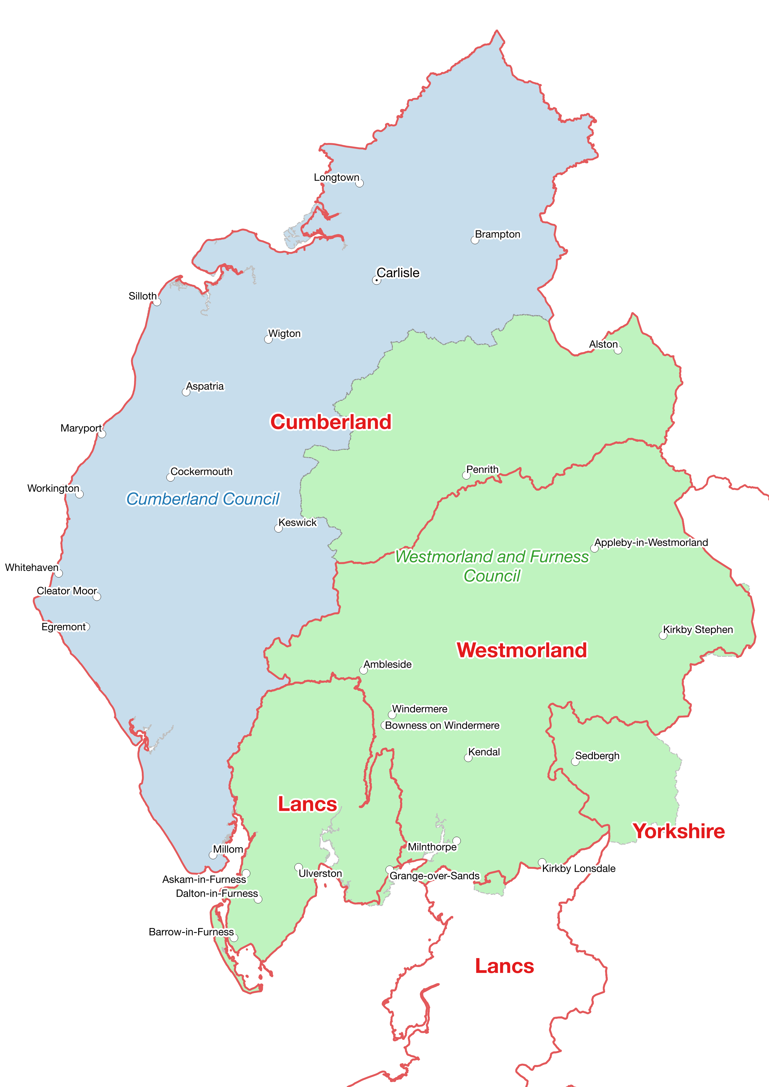
Whilst the area of Cumberland Council lies entirely within Cumberland, 23% of the historic county, is excluded and 28% of Westmorland and Furness Council’s area actually lies within the remit of the Cumberland administration. In addition 6% of the latter council’s area lies in the Sedbergh area of Yorkshire. Most disappointingly the Government decided to continue with the “Cumbria” lieutenancy area as shown below in yellow
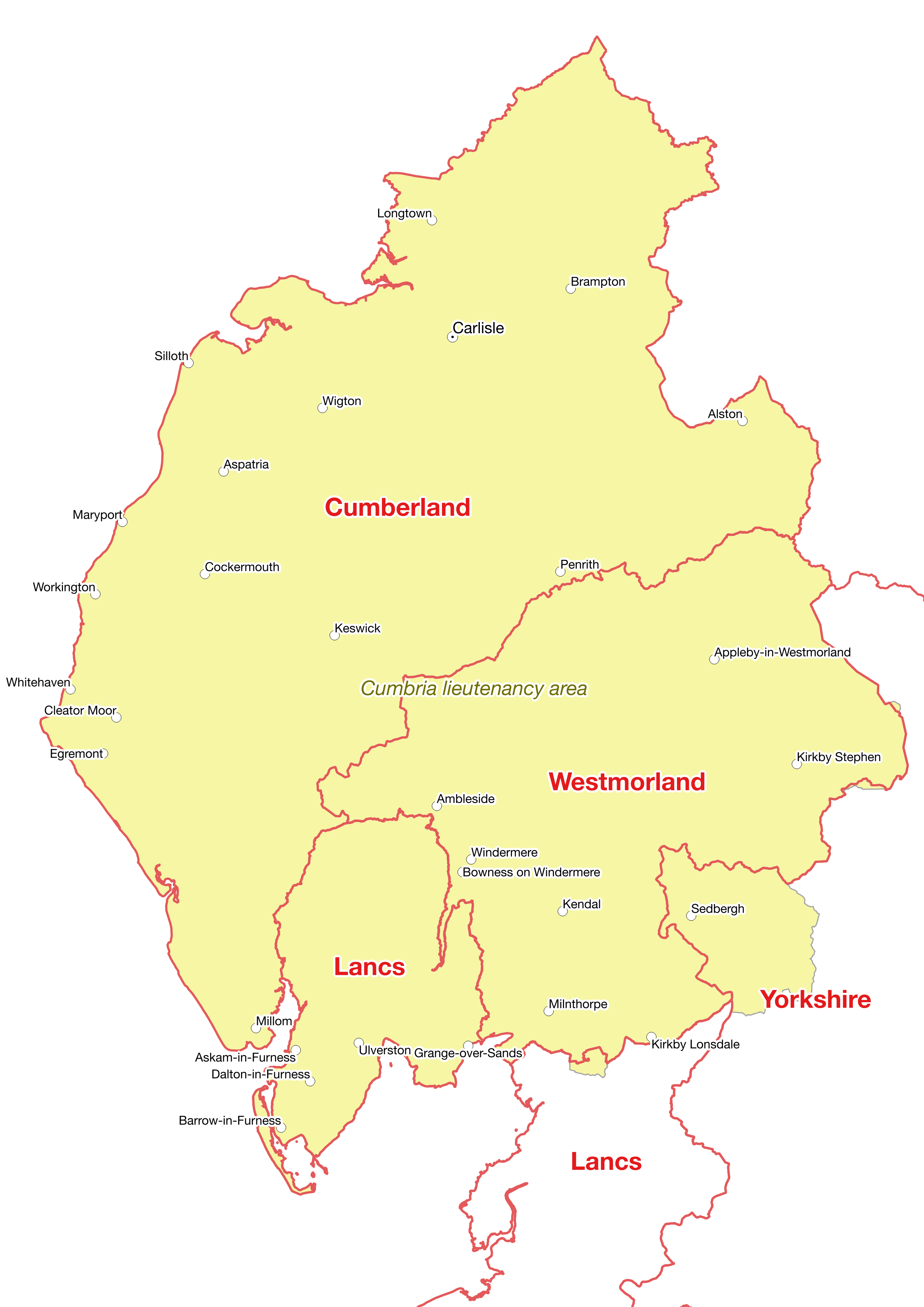
rather than basing “lieutenancies” on real counties, as depicted by red boundary lines. About which, more follows below.
Cambridgeshire and Huntingdonshire

Cambridgeshire County council’s administrative remit is depicted in the light beige colour and as can be seen, covers two counties, both Huntingdonshire and Cambridgeshire, although not all of either! To compound matters and even more absurdly, the ‘Cambridgeshire’ lieutenancy area differs again from that of the council
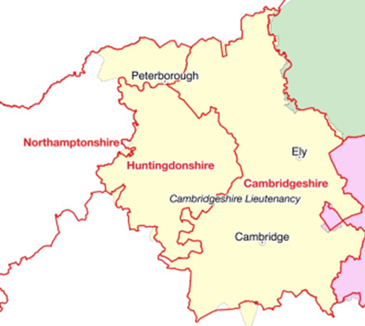 reflecting the fact that Peterborough was once administered by the Cambridgeshire council but is no longer. How much more sensible it would be to assign Lord Lieutenants to real counties as a ceremonial post best suited to promoting their heritage and culture. Administrative areas need no protection of heritage as they have none and are ever-changing.
Oxfordshire
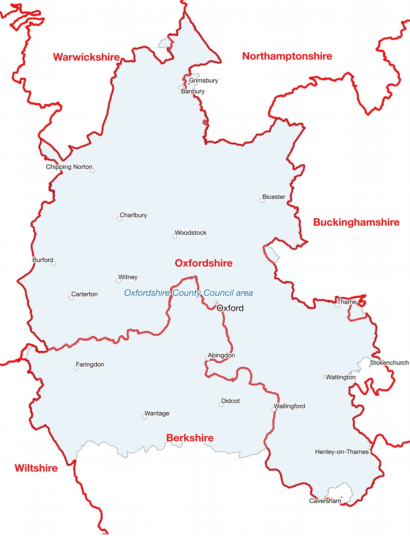 Oxfordshire County Council’s administrative remit includes a large section of Berkshire but its administration does not define Oxfordshire, whose southern boundary is and always has been the Thames. Abingdon and Farringdon are in Berkshire.
Denbighshire
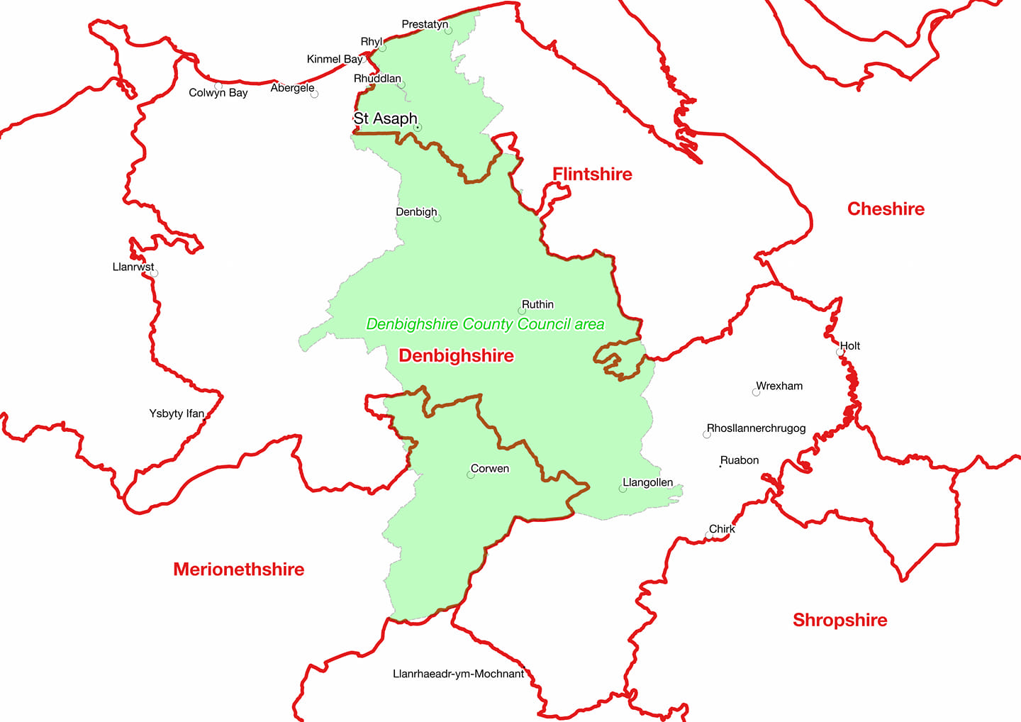
Use of the name Denbighshire, by the local authority running civic matters in the area coloured green, is strikingly absurd and wholly inappropriate. Denbighshire County Council barely covers a third of actual Denbighshire but does include areas of Flintshire to the north and Merioneth (Meirionnydd) to the south. People who comprehend “Denbighshire” from this administrative remit are completely misled.
Monmouthshire 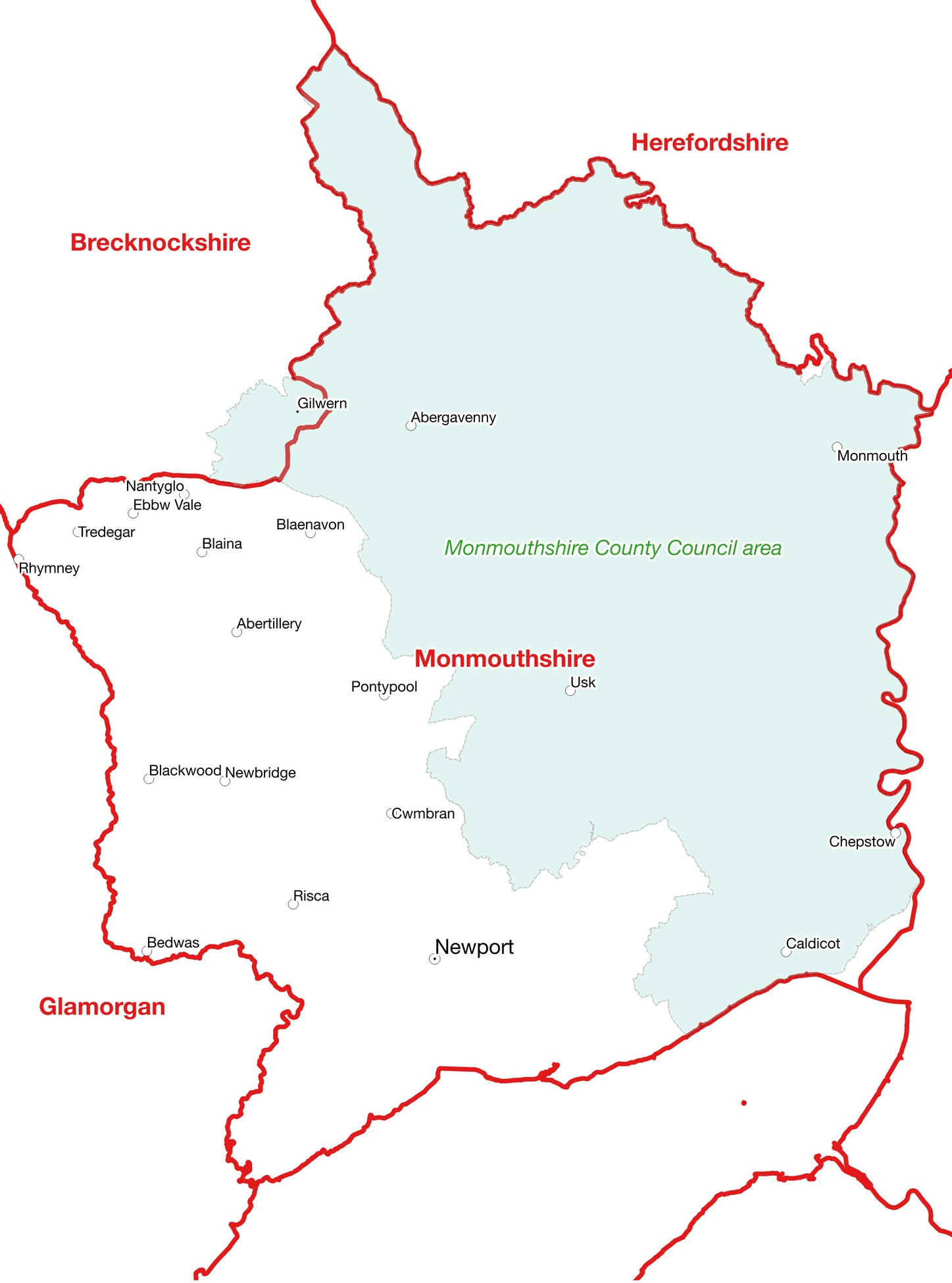 One of the administrative bodies within Monmouthshire calls itself Monmouthshire County Council, yet it administers barely half of the actual shire, its remit, which even extends across the county boundary to include a small portion of Brecknockshire, is depicted in a light blue-green shade on the above map. Use of the name Monmouthshire County Council by a body that does not actually cover the true county but does include another, is manifestly absurd.
Dumbartonshire
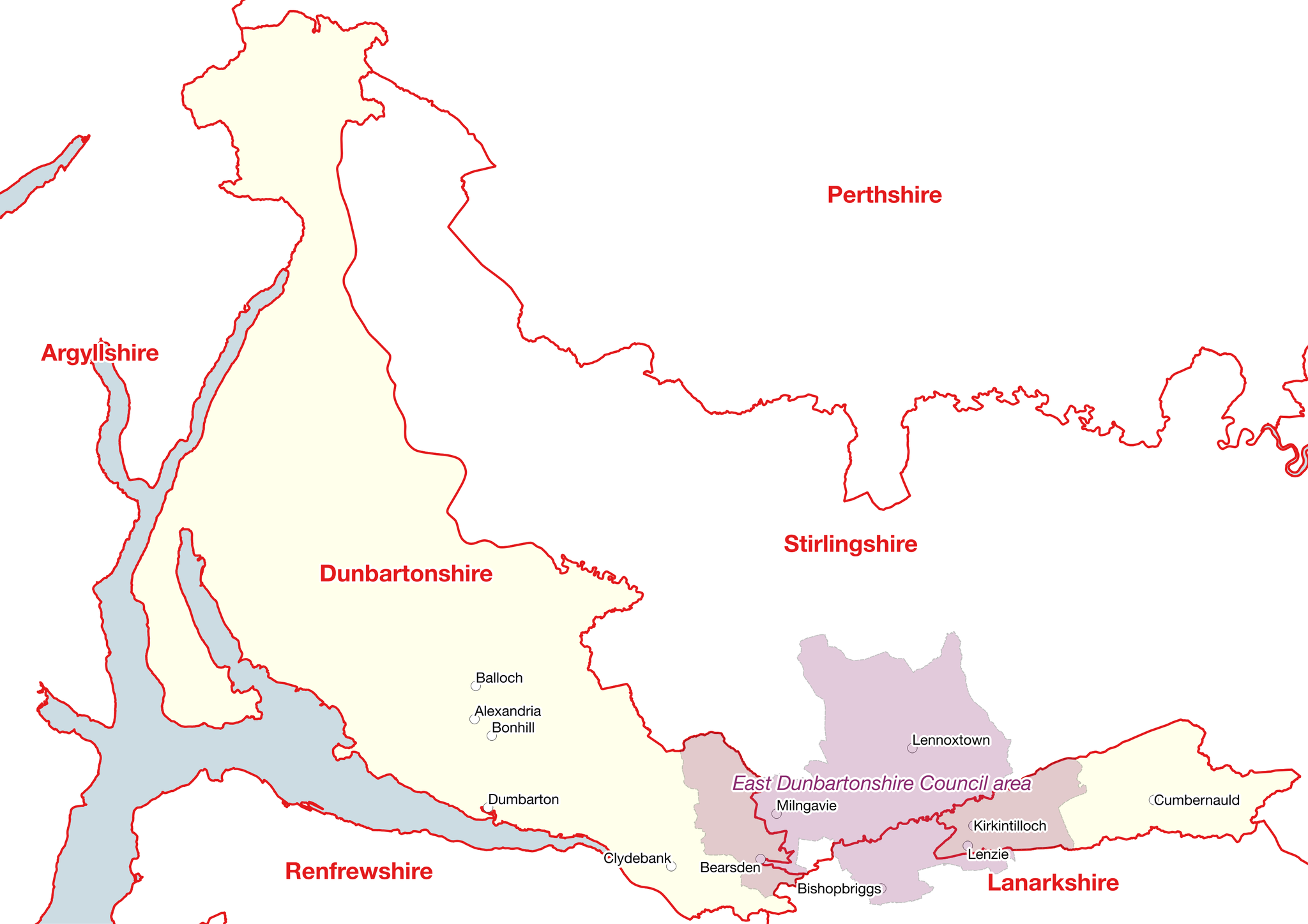
Perhaps the most glaringly inaccurate use of a county name by a local authority is that of East Dumbartonshire Council, most of whose territory sits in Stirlingshire.
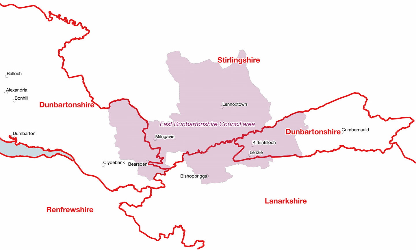
Dumbartonshire actually comprises two non contiguous territories, as can be seen. Additionally, the council’s remit includes a part of Lanarkshire, so its name is really obviously inaccurate and quite misleading.
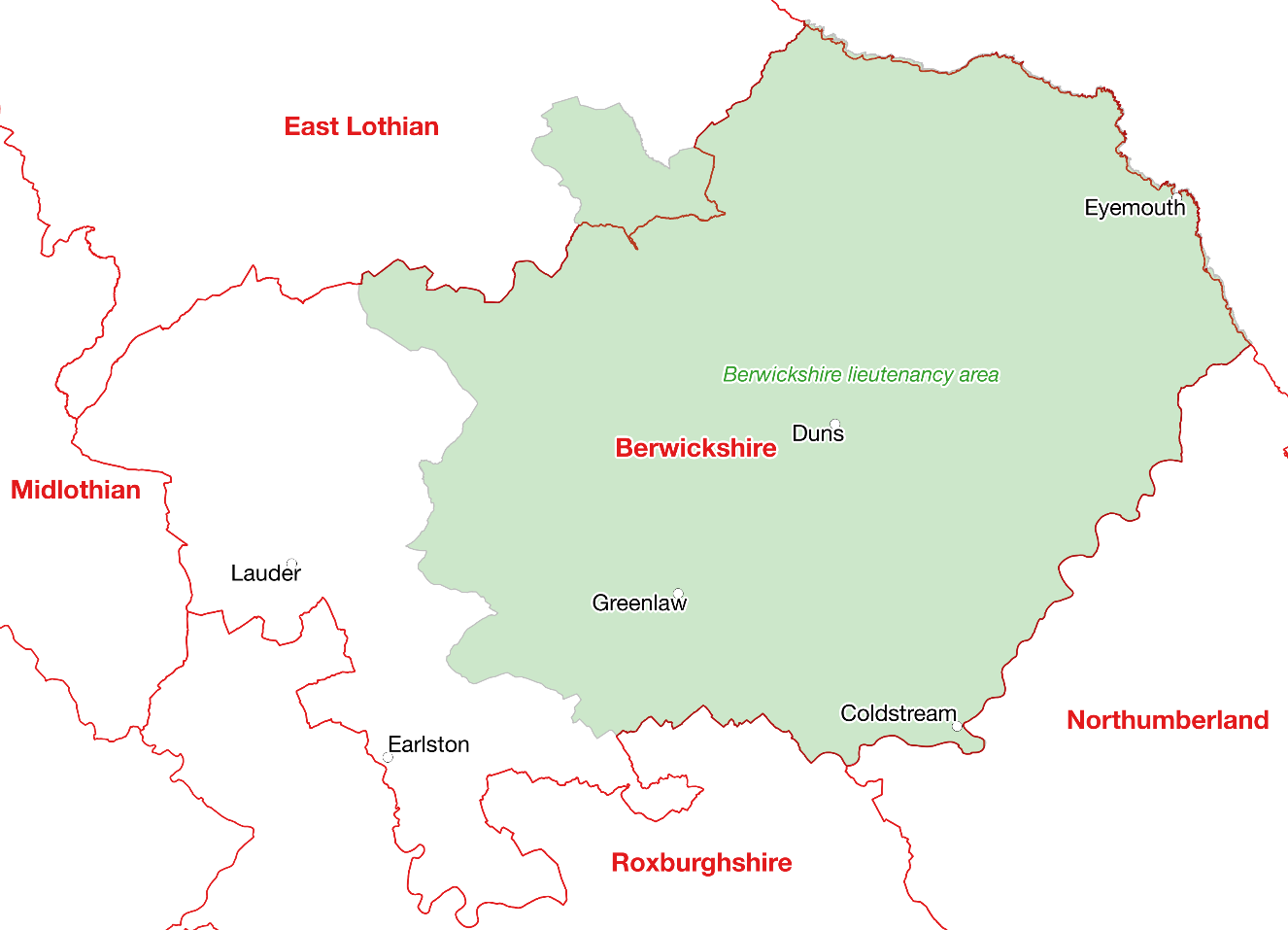
The green portion of the map below depicts the territory comprising the Berwickshire Lieutenancy area, which as can be seen, is not coterminous with the boundaries of the actual county depicted in red.
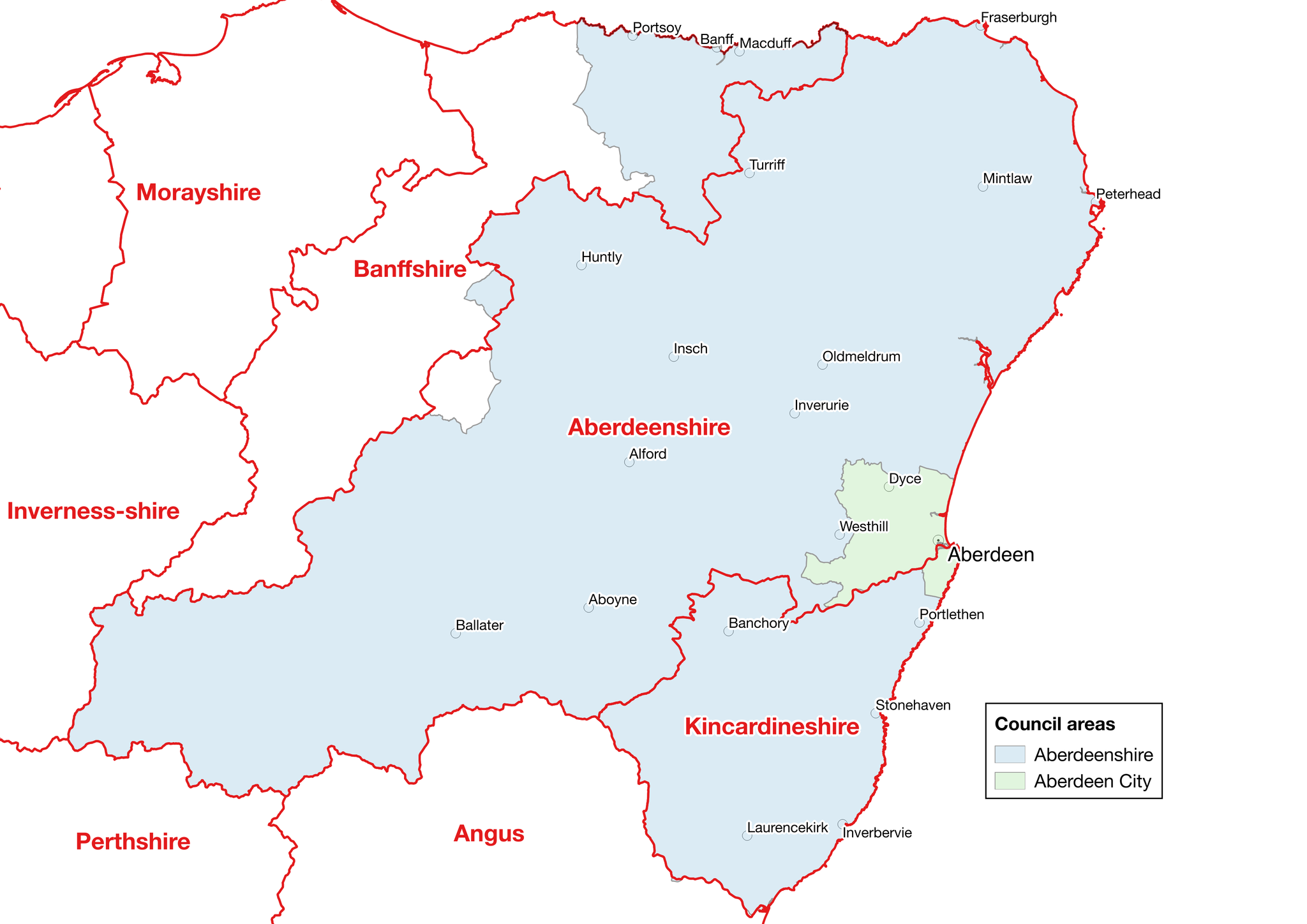
 Local Government areas in Scotland are at least called “council areas” and are not generally portrayed as counties, though some do make inappropriate use of an historic county name. As can be seen below, Aberdeenshire Council’s territorial remit, depicted in light blue, covers almost all of Kincardineshire and a big chunk of Banffshire but does not include Aberdeen!!!
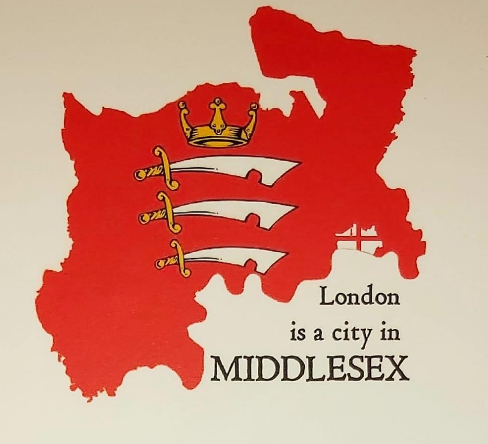
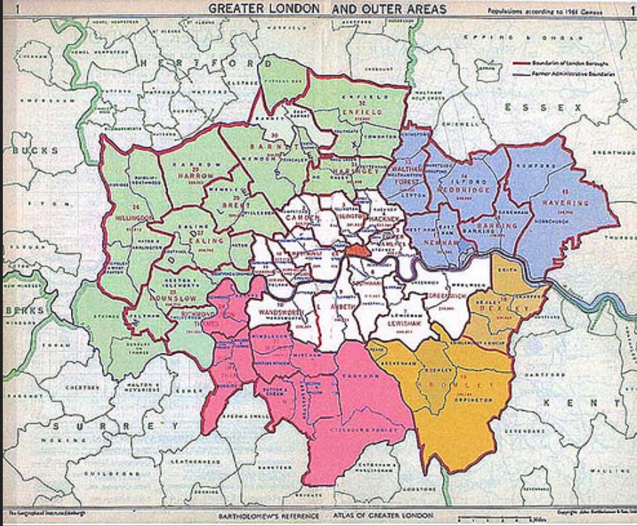
Middlesex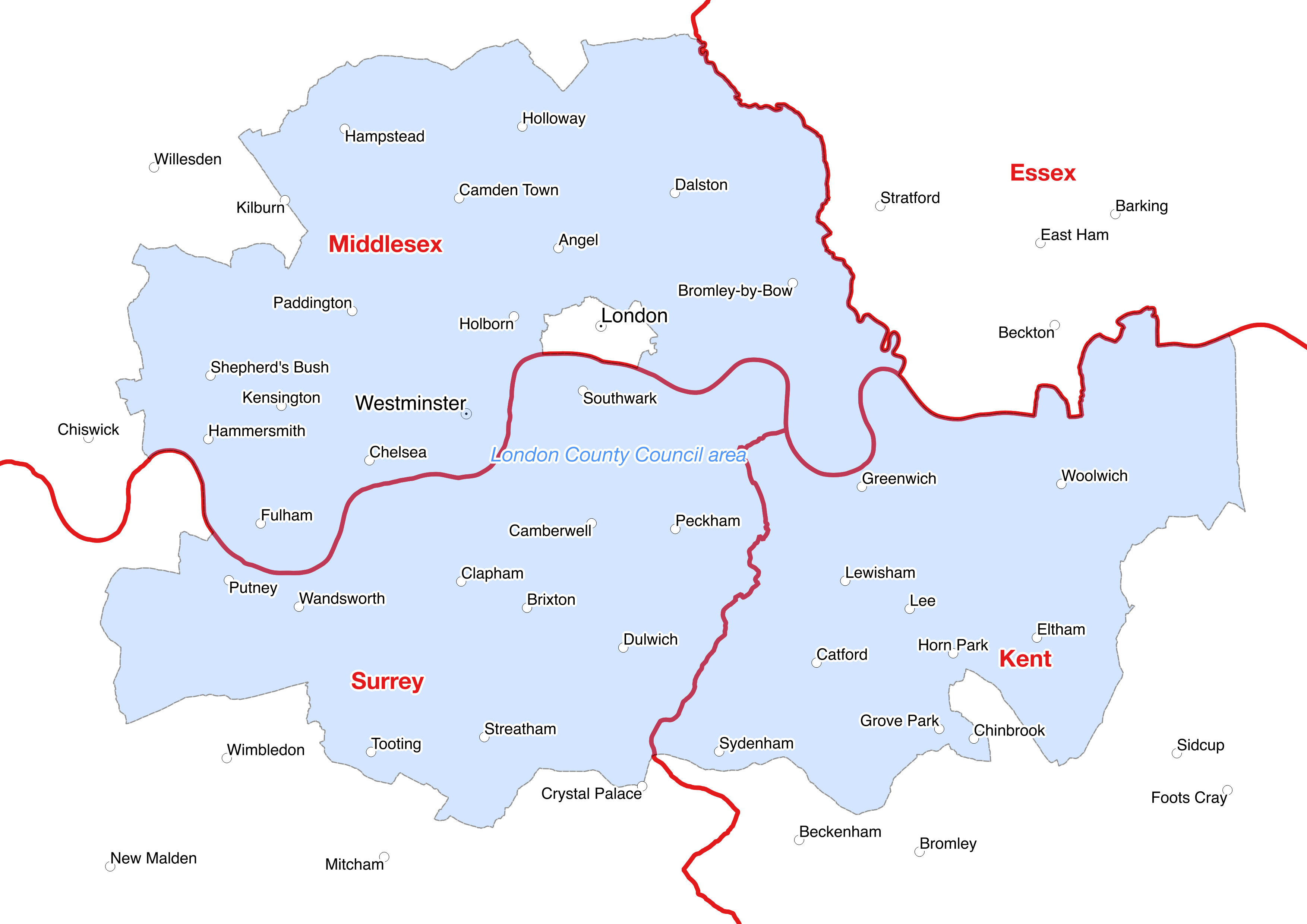
In 1889 a south eastern chunk of Middlesex was administratively hived off and combined with a north eastern part of Surrey and a north western part of Kent, to form an administrative London council (the London County Council or LCC), whose remit is depicted in the above map. This surrounded the original square mile of the City of London, shown in grey at the centre of the map but at no time did any of the three territories formally cease to be part of their respective counties, a fact which the following map and accompanying statement, emphatically conveys
 This measure was a purely administrative convenience and did not affect the territorial integrity of the counties concerned.
In 1965 the London authority remit was replaced by an expanded version (Greater London Council or GLC, later, Greater London Assembly or GLA)
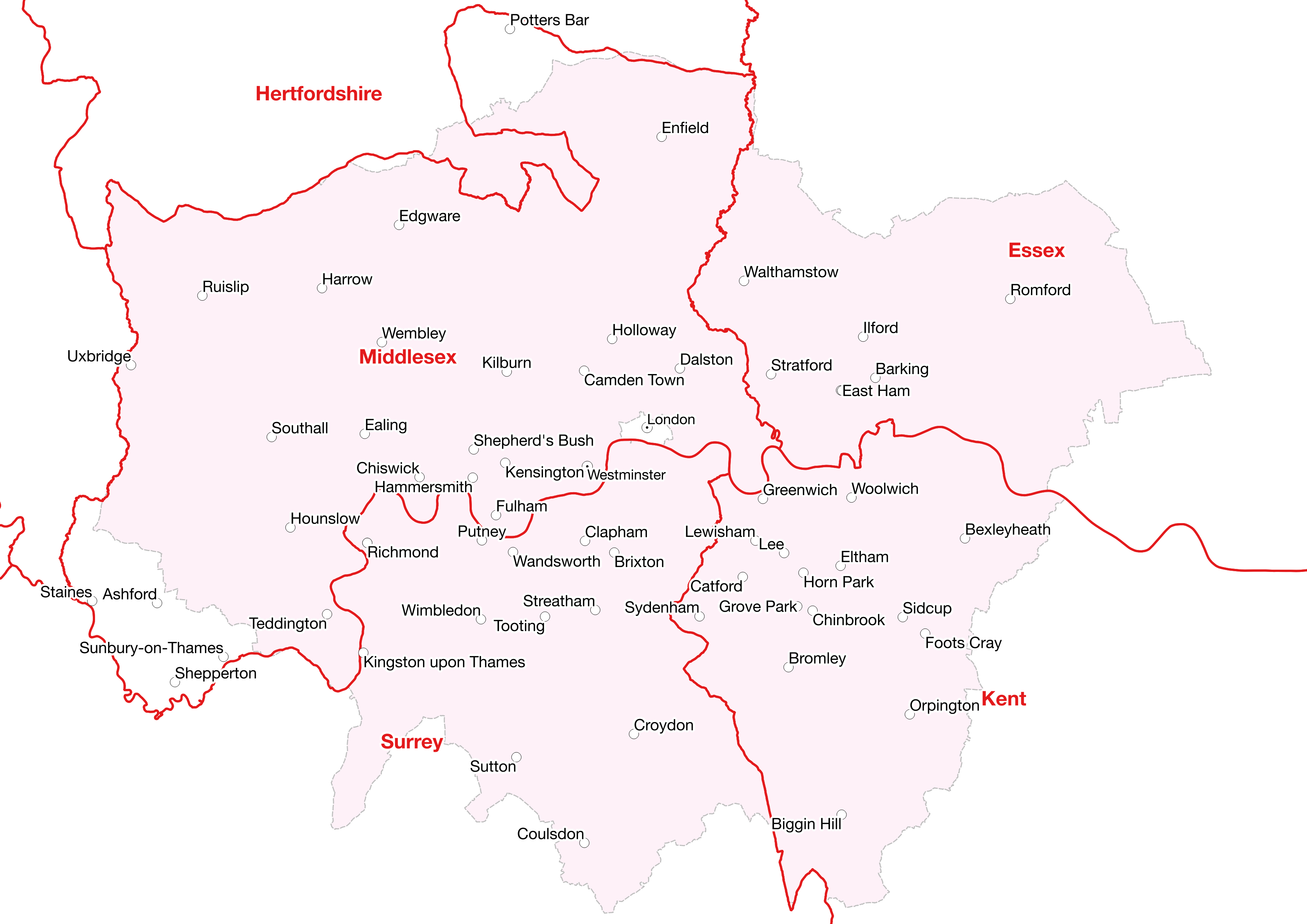 that embraced virtually the entirety of Middlesex and added parts of south west Essex and additional territory from Surrey, Kent and Hertfordshire.
This move also placed some parts of Middlesex within the administrative remits of Hertfordshire and Surrey county councils. Again, however, these administrative changes were purely that, they at no time affected the territorial integrity of the counties concerned, all the respective areas affected, remain to this day, as part of their original counties, no legislation has ever affected them. People sometimes ask what then is London? As these maps and the one below
clearly demonstrate, London is a city which straddles several counties at the point where they meet. This is demonstrated further by the extended county map of south east of England shown below.
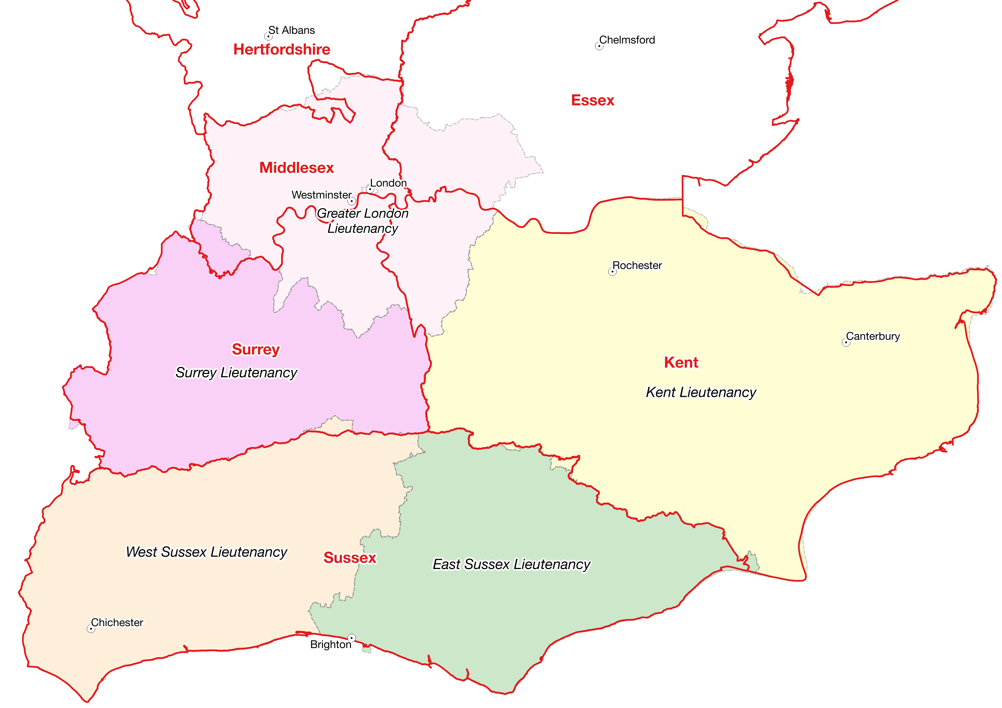
Surrey
Surrey County Council’s territorial remit, shown below in the light grey area
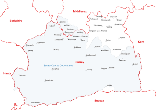
includes only 37% of the population of the historic county of Surrey! 8% of the population administered by Surrey County Council, actually lives in Middlesex, the similarly shaded territory, lying north of the Surrey county boundary, depicted in red. A great expanse of the county in the north east, from Richmond to Croydon, depicted above, in a lighter shade again, sits administratively within Greater London, as also seen in the previous maps but of course, this portion, remains part of the county of Surrey.
Surrey council will be abolished in May, 2027 and replaced by two administrative bodies with the territorial remits depicted below

Sussex
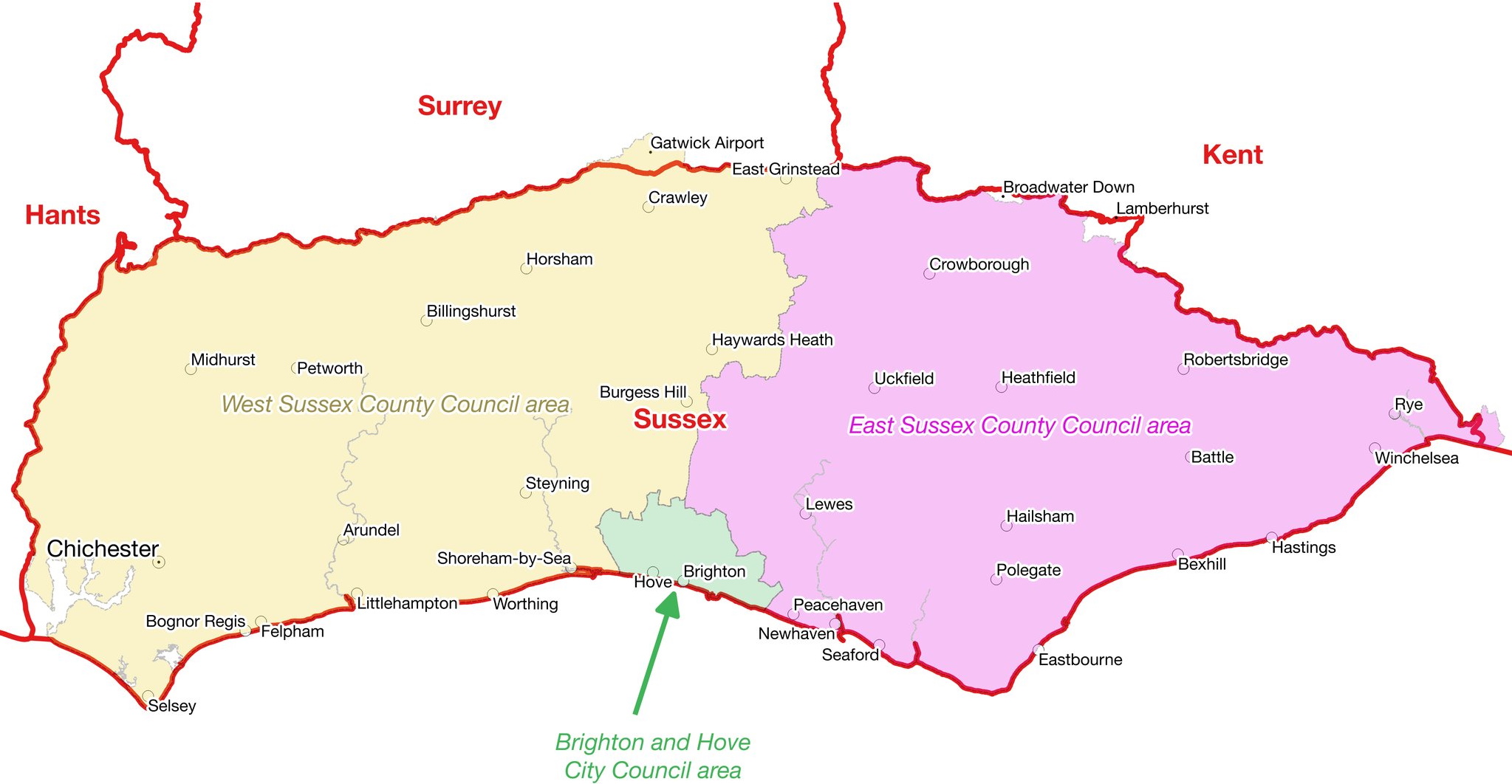 Sussex is one county, administered by three councils. The territory of none of these councils constitutes a county in itself. There is only one Sussex. As can be seen some territory across the county boundary is administered by Sussex based administrations and vice versa but the counties of Kent, Surrey and Sussex are unaffected by these administrative practicalities.
Kent

The Kent boundary is shown in red above, within this and in some locations, overlapping it, in lime green, is the territorial remit of Kent County Council. Whilst the local authority area is mostly within Kent, it doesn’t cover the metropolitan parts nor the Medway towns, which are administered by various authorities, depicted in different colours.
Hampshire, Wiltshire and Dorset
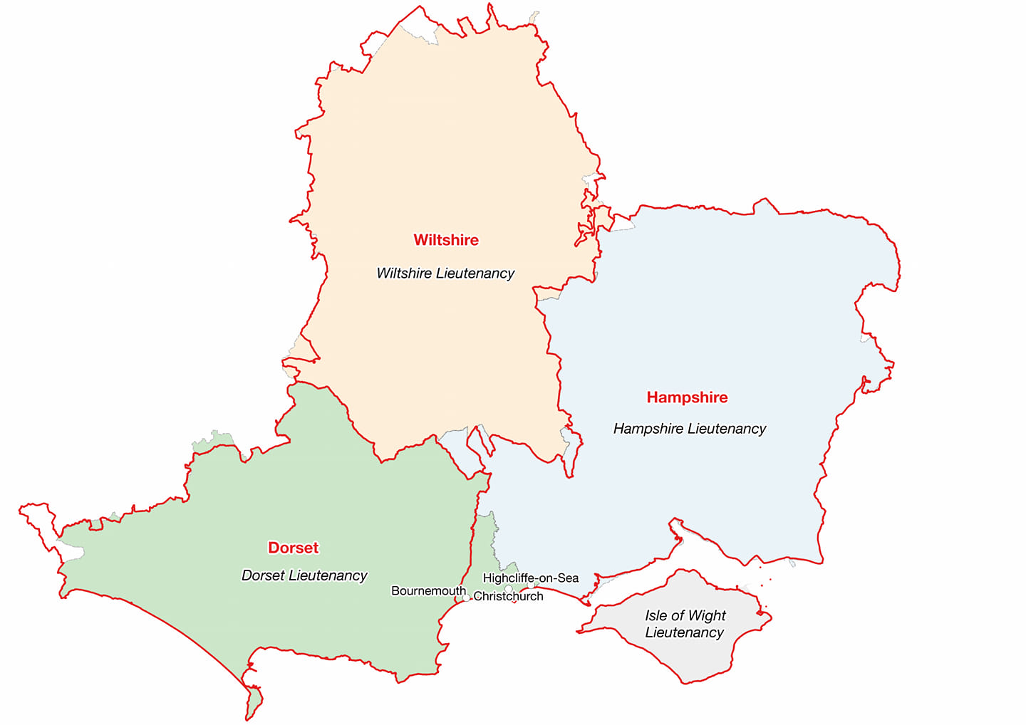

The administration of these counties has altered considerably and often, in the past decades but nothing has ever legally changed the fundamental arrangement of the counties. As can be seen in the second map, several local authorities operate within Hampshire and across its boundaries; Bournemouth, Portsmouth, Southampton and the Isle of Wight are self-administering but all remain part of Hampshire.
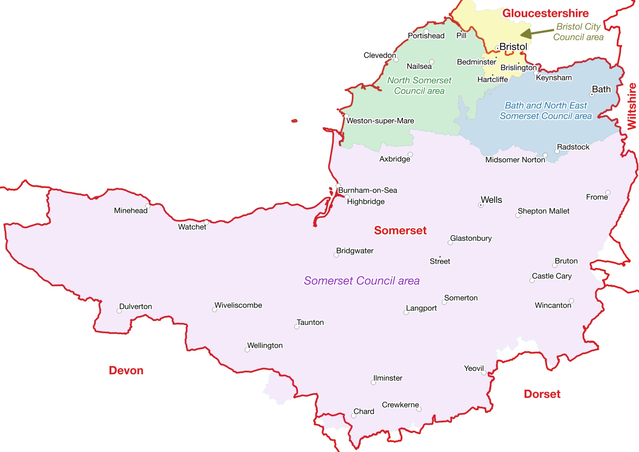
Somerset
The below map of Somerset

shows the true county boundary in a bold red line, within this the administrative remits of several councils as existed before 2023, are indicated in different colours. However, irrespective of administrative arrangements, the county of Somerset is still defined by the red boundary and not by the patchwork of local authority colours. NB The city of Bristol straddles the county boundary with Gloucestershire, i.e. the part which lies south of the old course of the River Avon, is in Somerset, to the north, it is in Gloucestershire. The combined area of “Somerset County Council”, “North Somerset Council” and “Bath and North-East Somerset Council” comprises the Somerset lieutenancy area but this is not the same as the actual, historic, county, either in kind or area. Furthermore, whilst many people believe that Bristol is a county in its own right, the accurate designation is in fact a “county corporate”, and derives from the city being granted a charter, which was actually concerned with the town’s judicial arrangements rather than its geographical status. The “county corporate” description has generally been seen as an extra dignity added to a town, not that the town has literally been removed from its host county. For example, the General Register Office, within its Census Reports, never considered them to be so and always dealt with them as being part of the County in which they geographically lay. Numerous legal judgments have also found that the “counties corporate” were not “Counties in the ordinary sense of the term”. More details on this are available here.
On April 1st 2023 a new local authority replaced somerset County Council, although with the same territroial remit, the only significant difference was the nonetheless welcome removal of the word “county ” from the title of the revamped body.